Meall Ghaordaidh(1039m)
Saturday 17th May 2014
10kms
5hrs
When we climbed Meall Ghaordaidh last, on the 6th Jan 2013, it was a wet, cloudy day with little visibility above 600m, and a very strong wind which almost grounded us on the summit. I managed to take a total of 6 photographs to record on that walk. Today, I was hoping for something a little better, after all this was May and not January.
The observant among you may have already worked out how the day went! The lack of photos opposite being a big hint. The weather was almost identical to our previous visit, even down to some snow patches still filling the higher gullies, with the rain, if anything, heavier and more prolonged. So much for May sunshine.
As seems to be the case with Meall Ghaordaidh, parking at the start of the walk is always a challenge, but we just managed to squeeze our 3 cars into what space was available, 2 other cars having beaten us to the prime spot. And so, boots and waterproofs on, the 12 of us set off across the two lower fields towards the stile and the open hillside track that would take us steadily uphill towards the old shielings.
Just short of the shielings, a small cairn by the track, and a single iron fence post situated a little away from the track side mark the point at which to leave the track and take to the broad, open, and often very boggy ground for what is a fairly easy, but lengthy walk up the rough heather clad hillside. With very limited visibility, there is little to indicate that you are climbing a mountain of Munro status, and Ian's description of "like walking over a broad moorland" very adequately sums up the lower slopes of this mountain.
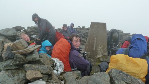
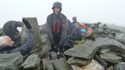
The perception changes slightly as you reach the 800m height, when a series of small crags appear, and the ground becomes more rocky underfoot, the incline however remains fairly gentle as you make the final approach towards the summit Trig Point, enclosed as it is in a circular stone shelter. With a touch of deja vu the summit was lashed in wind and rain, just as on our previous visit.
Our initial intention had been to make our return via the ridge to Cam Chreag, but given the conditions, we decided to opt for a direct return and therefore, once again, we stayed on the summit just long enough for everyone to regroup before we turned tail and retraced our steps back downhill to huddle behind some tall crags in order to have our lunch break.
Conditions remained bleak for the return downhill, and we were a very wet looking lot as we arrived back at the cars, just as the occupants of the other 2 cars also re-appeared from the hillside - they weren't a very talkative lot, so although they may well have been on the same hill as us for the day, we never did find out - all I can say is, we were wet and cheerful, they were just wet!
Never mind, a pot of tea, with a scone and jam beside a roaring fire (yes a fire in May) in the Bridge of Lochay Hotel soon warmed everyone up.
Great day Ian, despite the weather - Thanks everyone
Stop Press!! - Ian has saved the day and sent me 2 photos he took at the summit, so, all is not lost!