Ben Oss from Glen Falloch(1029m)
Sunday 31st August 2014
22kms
8hrs 30mins

Ben Oss was the only remaining Munro of the group of four, Beinn a'Chleibh, Ben Lui, Beinn Dubhchraig and Ben Oss, that I still had to climb. Almost invariably, Ben Oss is climbed from the north east with a start point at Dalrigh, and often in conjunction with an ascent of Beinn Dubhchraig. However, from a conversation some time ago with Alan, the seed was sown for making an approach from Glen Falloch, to the south. And so, with a promising weather forecast, a Sunday without a scheduled walk, a route I had planned out quite carefully and 3 very welcome friends to accompany me, off we set from the car park at the Falls of Falloch.
The words "careful planning" may not have been in the minds of my companions as we passed under the WHR via the sheep creep and were plunged waist deep in rough grass and scrub, struggled to get across the waters of the Allt Fionn Ghlinne, and upwards in still more waist deep grasslands. But fear not thee of little faith - all would be made clear as we gained a good track above the river, a track which does not appear on any of my OS maps, but which heads up into Fionn Ghleann to a rather new looking dam and water intake, again, not shown on any of my maps.
Thanks to this track, the rough hillside is traversed quite quickly, and beyond the small dam the going levels as you now continue along the west bank of the Allt Fionn Ghlinne into an ever widening glen, with wonderful views of the mighty southern flank of Beinn Dubhchraig dominating the skyline ahead. At around the 350m height, the river changes quite suddenly, from slow and calm, to quite a torrent as it plunges down towards you from a tree-lined gorge, at which point, it not only changes in appearance, but also in name, now taking on the title of Sput Ban.
A relatively easy climb took us up the side of the gorge and once above the waterfall we found ourselves a reasonable crossing point to take us over to the east bank of the river, where the gradient again levels off as you cross the broad heather clad moorland towards the vast arc of a bowl created by the sweep of hillside from Ben Oss, around Bealach Buidhe and onto Beinn Dubhchraig. Strangely enough, the river again changes its name and becomes the Allt Oss as it flows down from its head in Loch Oss towards Sput Ban.
Loch Oss itself remains stubbornly hidden until you crest the lip of the rise that you have been steadily heading towards since crossing the river. but on arrival you are not disappointed, as it is a rather beautiful loch, with a small island a short way off-shore, and some reed beds forming a curve in the still waters just off the northern point of the loch. A lovely spot that just beckoned us to take a break alongside the small stream emerging from the grassy gully up which we would make our way to the 941m north east top of Ben Oss.
Although we had climbed from almost sea level to Loch Oss at 650m height the gradients had been very gentle, and so the 300m ascent from the loch shore to the north east top was the first, and only, point of the day where we actually felt you were tackling a Munro, and this only for a very brief period of time, as we soon found ourselves arriving at the small cairn which marks this un-named top.
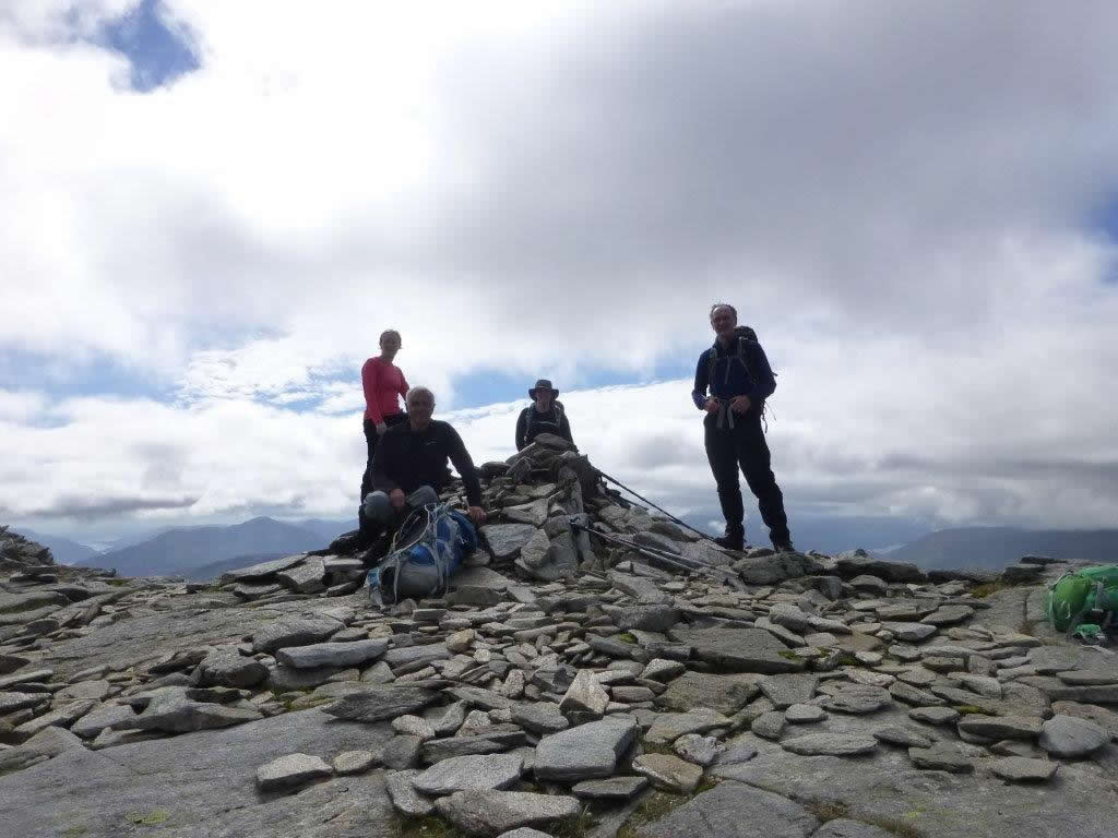
As we were now on the standard route taken by those making the transit from Beinn Dubhchraig to Ben Oss, or vice-versa, the final ascent to the main summit was over a well worn and well defined rocky path, up the ridge towards the summit cairn, at 1029m. The weather had held very fair for us, with only a few periods when the clouds drifted down onto our summits, but, our arrival was cloud free, with the exception of the neighbouring Ben Lui, which still wore a crown of light cloud around its summit.
The views were fantastic, as we looked east the whole range from Ben More, Cruach Ardrain, An Caisteal, Beinn Chabhair and Ben Lomond prominent, with, sitting in the far background beyond them all, Ben Vorlich (Lochearnhead). While, in the west, all from Loch Awe through Glen Fyne and onto Loch Lomond was clearly visible. A great window to look out from our lunch spot just below the summit ridge.
Our descent route took us almost directly south from the summit, down easy grassy slopes to pick up the head of a very prominent gully, which dropped quite steeply down towards an old track which just materialises in the middle of the hillside, and leads down to the more defined and very good hydro pipeline access track in Gleann nan Caorann. It is still quite a walk out along this track, but the going is easy, and the views are ever changing as you approach Glen Falloch and emerge below the high point of Troisgeach Bheag and the final short stretch back along the A82 to the start point at the Falls of Falloch.
A thoroughly enjoyable day - Thanks to Lindsay, Janet and Mike for their company, and an additional thanks to Mike for supplementing the few photos I managed on my phone due to my camera mysteriously refusing to function.
Route Update: When I did a very short 2 hour recce over the start of this walk last Wednesday I initially passed through the sheep creep under the WHR and started to head up the east side of the Allt Fionn Ghlinne. The going was very, very rough, and as I gained height I could see a track appearing on the opposite side of the river, a track that was not on my map. Eventually I gave up on the east side and scrambled down, over the river, and up to the track, which I then followed to the un-marked dam further up the glen, before going on towards Sput Ban. As we returned down Troisgeach Bheag on Sunday, we could clearly see work taking place (probably pipeline related) on the hillside above Glen Falloch, and a good access track running towards Fionn Ghleann, which joined with the track we had used to get to the dam.
Therefore, for anyone contemplating this route, or indeed if I put it into next years summer programme, I would make the following changes:
Start from the track on the A82 at NN320 198 - on the map this track is shown as ending abruptly at NN323 207 - however, this is in fact the track which continues into Fionn Ghleann and ends at the dam at NN323 223 - Click HERE to see the route map for the amended route.
This change makes virtually no difference to the overall distance, in fact it is probably a few hundred metres shorter, and it negates the need for the rough start beyond the sheep creep and for the walk back along the busy A82 at the end of the walk.